
Application of the Flood Guidance Model (FG) in the Yi River basin in Uruguay
DOI:
https://doi.org/10.31285/AGRO.27.1191Keywords:
flood warnings, satellite imagery, antecedent precipitation index, rural floodingAbstract
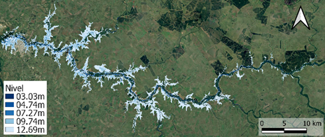
This study focuses on the application/adaptation of the Flash Flood Guidance (FFG) model developed by the National Weather Service (NWS). The FFG is defined as the total amount of rainfall of a given duration sufficient to cause bankfull flow at the outlet of the watershed. Since flash floods do not occur in Uruguay due to the slower hydrologic response of the watershed, an adaptation of the above model is evaluated and renamed Flood Guidance (FG). Nine storm events that occurred between 2014 and 2020 in the Yi River basin in Uruguay were analyzed. The Natural Resources Conservation Service (NRCS) Curve Number model, a simple and widely used model, is used to determine effective precipitation. Two alternatives are considered to determine the antecedent soil moisture: the use of an antecedent precipitation index (API), and the use of SMOS satellite imagery. The FG is then calculated and compared to the precipitation forecast to determine if there is a risk of flooding at the watershed outlet. The results are compared to observations to evaluate the quality of the warning forecast. The application for forecasting flooded rural and agricultural areas using Sentinel-2 satellite imagery and the NDWI index is considered and analyzed.
Downloads
References
Arnold JG, Williams JR, Nicks AD, Sammons NB. SWRRB: A Basin Scale Simulation Model for Soil and Water Resources Management. Texas: Texas A&M Press; 1990. 252p.
Barrenechea P, Saráchaga D. Evaluación económica de costos de las inundaciones en Durazno, Soriano y Treinta y Tres [Internet]. Montevideo: Sistema Nacional de Emergencias; 2008 [citado 2024 Feb 3]. 10p. Disponible en: http://www.preventionweb.net/files/15250_5costosinundacionespedrobarrenechea.ppt
Chow VT, Maidment DR, Mays LW. Applied Hydrology. New York: McGraw-Hill; 1988. 572p.
Durán A. Clasificación hidrológica de los suelos del Uruguay. Agrociencia. 1997;1(1):15-29. Doi: 10.31285/AGRO.01.1009. DOI: https://doi.org/10.31285/AGRO.01.1009
Durán A. Los suelos del Uruguay. 2a ed. Montevideo: Hemisferio Sur; 1991. 398p.
Georgakakos KP, Modrick-Hansen TM, Shamir E, Cheng Z. Verification Guidelines for the Flash Flood Guidance System component products and derivative warnings. San Diego: HRC; 2019. 113p.
Hawkins RH, Ward TJ, Woodward DE, Van Mullem JA, editores. Curve Number Hydrology: State of the practice. Reston: ASCE; 2009. 115p. DOI: https://doi.org/10.1061/9780784410042
Ministerio de Ambiente, DINAGUA (UY). Manual de diseño y construcción de pequeñas presas [Internet]. Montevideo: MVOTMA; 2011 [citado 2023 Set 13]. Disponible en: https://bit.ly/4biN1SR
Mishra SK, Suresh Babu P, Singh VP. SCS-CN method revisited. En: Advances in Hydraulics and Hydrology. Littleton: Water Resources Publication Colorado; 2007. 36p.
Moglen GE, Sadeq H, Hughes LH, Meadows ME, Miller JJ, Ramirez-Avila JJ, Tollner EW. NRCS Curve Number Method: comparison of methods for estimating the curve number from Rainfall-Runoff Data. J Hydrol Eng. 2022;27(10). Doi: 10.1061/(ASCE)HE.1943-5584.0002210. DOI: https://doi.org/10.1061/(ASCE)HE.1943-5584.0002210
Narbondo S. Incorporación de información satelital de humedad del suelo en modelo hidrológicos para pronóstico de inundaciones en cuencas del Uruguay [tesis de maestría]. Montevideo (UY): Universidad de la República, Facultad de Agronomía; 2021. 117p.
Petraglia C, Dell’Acqua M, Pereira G, Yussim E. Mapa integrado de cobertura / uso del suelo del Uruguay, año 2018. En: Anuario OPYPA 2019. Montevideo: MGAP; 2019. p. 523-31.
Saxton KE, Rawls WJ. Soil water characteristic estimates by texture and organic matter for hydrologic solutions. Soil Sci Soc Am J. 2006;70(5):1569-78. DOI: https://doi.org/10.2136/sssaj2005.0117
Saxton KE, Willey PH, Rawls WJ. Field and pond hydrologic analyses with the SPAW model. Contribución presentada en 2006 ASABE Annual Meeting; 9 - 12 July 2006; Portland, Oregon, US. Doi: 10.13031/2013.20709. DOI: https://doi.org/10.13031/2013.20709
Shepard D. A two-dimensional interpolation function for irregularly-spaced data. En: Proceedings of the 1968 23rd ACM national conference. New York: ACM Press; 1968. p. 517-24. DOI: https://doi.org/10.1145/800186.810616
Shi W, Wang N. Improved SMA-based SCS-CN method incorporating storm duration for runoff prediction on the Loess Plateau, China. Hydrol Res. 2020;51(3):443-55. DOI: https://doi.org/10.2166/nh.2020.140
Silveira L, Chreties C, Crisci M, Usera G, Alonso J. Sistema de alerta temprana para previsión de avenidas en la ciudad de Durazno. INNOTEC. 2015;(10):56-63. Doi: 10.26461/10.05. DOI: https://doi.org/10.26461/10.05
Silveira L, López G, Chreties C, Crisci M. Steps towards an early warning model for flood forecasting in Durazno city in Uruguay. J Flood Risk Manag. 2012;5(3):270-80. DOI: https://doi.org/10.1111/j.1753-318X.2012.01146.x
Silveira L, Terra R, Usera G, Chreties C, López G, Crisci M, De Vera A, Symonds S, Rodriguez G, Piperno A, Sierra P, Osimani V, Francisco A, Garcia P, Sabaño O, Matos A, Alcoz S, Irazábal B, Rodríguez JM, Garcés C, Patrone J, Platt A, Failache G, Queirolo JL, Cortese W, Aldana JL, Pedocchi R. Proyecto piloto PROHIMET: alerta temprana para la ciudad de Durazno ante las avenidas del río Yí. Montevideo: Fundación Julio Ricaldoni; 2012 [citado 2024 Feb 3]. 208p. Disponible en: https://drive.google.com/file/d/1O5OoWYsApEYdHQdMh0sxSUCBPbvSca8e/view?usp=drive_web
Silveira L, Usera G, Cazes G, Chreties C, Alonso J, Crisci M, De Vera A, Rodríguez G, Perazza G, Menta A, Narbondo S, Sierra P, Piperno A, Álvarez J, Amado M, Lejtreger R, D’Ambrosio M, López N, Cabrera M, Barrenechea P. SATI-Uy: Sistema de Alerta Temprana para previsión y gestión de inundaciones. Montevideo: Universidad de la República; 2017. 56p.
United States Department of Agriculture, NRCS. Hydrographs. En: National Engineering Handbook: Part 630- Hydrology [Internet]. Washington: NRCS; 2007 [citado 2024 Feb 3]. 50p. Disponible en: https://www.hydrocad.net/neh/630ch16.pdf
Woodward DE, Hawkins RH, Jiang R, Hjelmfelt Jr, AT, Van Mullem JA, Quan QD. Runoff curve number method: examination of the initial abstraction ratio. En: World Water & Environmental Resources Congress 2003. Reston: ASC; 2003. 10p. Doi: 10.1061/40685(2003)308. DOI: https://doi.org/10.1061/40685(2003)308
World Meteorological Organization. Manual on flood forecasting and warning [Internet]. Geneva: WMO; 2011 [citado 2023 Set 1]. 142p. Disponible en: https://library.wmo.int/idurl/4/35881
Downloads
Published
How to Cite
Issue
Section
License
Copyright (c) 2024 Agrociencia Uruguay

This work is licensed under a Creative Commons Attribution 4.0 International License.

| Article metrics | |
|---|---|
| Abstract views | |
| Galley vies | |
| PDF Views | |
| HTML views | |
| Other views | |