Baseline of the outcropping Guarani Aquifer System in Rivera and Tacuarembó, Uruguay
Piezometry and Vulnerability
DOI:
https://doi.org/10.31285/AGRO.26.507Keywords:
baseline, Guaraní Aquifer System, vulnerability, contamination riskAbstract
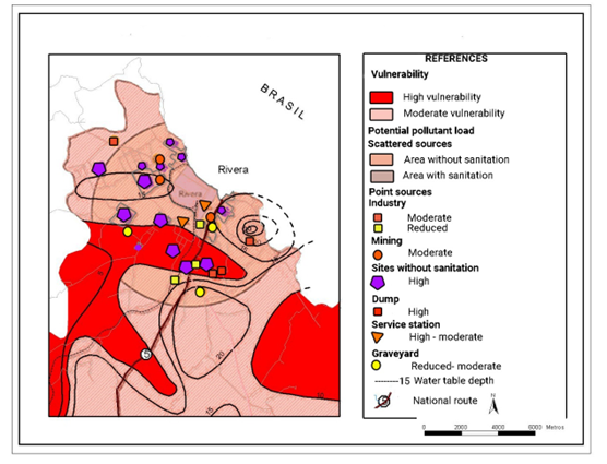
The piezometric, water table and vulnerability baseline of the outcropping Guaraní Aquifer System (GAS) in the departments of Rivera and Tacuarembó (Uruguay) is presented. The flow network and chemical composition are essential to understanding underground dynamics and identifying recharge and discharge zones, preferential flow directions, and determining hydraulic gradients. It is essential to analyze its evolution in time and space from the baseline, for the management and protection of the resource. Vulnerability was determined by applying the GOD and EKv methods, obtaining similar results, with areas of high and moderate vulnerability in most of the studied area. The risk of groundwater contamination was determined using the method of Foster & Hirata(34), obtaining high risk for potentially polluting loads from lack of sanitation, solid household waste, irregular settlements, and gas stations, in areas of moderate and high vulnerability. Industrial and mining activity and a cemetery represent a moderate risk in most cases. Having maps of vulnerability and risk of groundwater contamination is essential to identify the most vulnerable areas and implement detailed study, control, and protection tools aimed at conserving and mitigating impacts on GAS.
Downloads
References
Auge M. Vulnerabilidad de acuíferos: conceptos y métodos [Internet]. Buenos Aires: HidroRed; 2003 [cited 2022 Mar 22]. Availble from: https://bit.ly/3wyaKwE.
Bessouat C, Castagnino G, De Los Santos J, Robano M. Acuifero Raigón: carta de vulnerabilidad. Montevideo: IMFIA; 1999. 22p.
Bossi J, Ferrando L, Montaña H, Campal N, Morales H, Gancio F, Schipilov A, Piñeyro D, Sprechmann P. Carta Geológica del Uruguay: Escala 1/500.000. Montevideo: Geoeditores; 1998. 37p.
Bossi J, Navarro R. Geología del Uruguay. Montevideo: Universidad de la República; 1991. 2v.
Collazo P. Investigación hidrogeológica del Acuífero Guaraní en el área aflorante de los departamentos de Rivera y Tacuarembó, Uruguay [doctoral’s thesis]. Buenos Aires (AR): Universidad de Buenos Aires, Facultad de Ciencias Exactas y Naturales; 2006. 146p.
Collazo P, Pamoukaglhian K, Chiglino L. Guaraní Aquifer System sedimentary petrography of outcropping formations and hydrogeologic implications. Agrociencia Uruguay. Forthcoming 2022.
Collazo R, Auge M, Montano J. Vulnerabilidad y riesgo hidrogeológico del Sistema Acuífero Guaraní en el Área Aflorante de Rivera, Uruguay. In: Acuífero Guaraní: avances en el conocimiento para su gestión sustentable. Montevideo: ALHSUD; 2007. p. 157-73.
Custodio E, Llamas E. Hidrogeología Subterránea. Vol. 1. Barcelona: Omega; 1983. 1157p.
De Los Santos JE, Custodio E, Flaquer A, Giménez M, Menta A, Bessouat C. Gestión ambiental del Sistema acuífero Raigón. Montevideo: INIA; 2019. 48p. (Serie FPTA; 307).
Ferrando L, Andreis R. Nueva estratigrafía en el Gondwana de Uruguay. In: Actas I Congreso Latinoamericano de Hidrocarburos. Buenos Aires: ARPEL; 1986. p. 295-323.
Foster S. Fundamental concepts in aquifer vulnerability, pollution risk and protection strategy. In: Van Duijvenbooden W, Van Waegeningh HG, editors. Vulnerability of Soil and Groundwater to Pollutants. The Hague: Committee on Hydrological Research; 1987. p. 69-86.
Foster S, Hirata R. Determinación del riesgo de contaminación de aguas subterráneas. Lima: CEPIS; 1991. 79p.
Foster S, Hirata R, Andreo B. El concepto de vulnerabilidad a la contaminación acuífera: ¿ayuda o impedimento para la promoción de la protección de las aguas freáticas? [Internet]. 2013 [cited 2022 Mar 22]. Available from: https://bit.ly/3IIR6A.
Gonzalez L. Estudio de la vulnerabilidad y perímetros de protección del acuífero Chuy, en el balneario La Paloma (Rocha) [grade’s thesis]. Montevideo (UY): Universidad de la República, Facultad de Ciencias; 2011. 75p.
Hirata R, Bastos C, Rocha G. Mapeamiento da vulnerabilidade e risco de poluiçao das aguas subterraneas no Estado de Sao Paulo. Vol. 1. Sao Paulo: Instituto Geológico; 1997. 1144p.
Montaño J. Recursos hídricos subterráneos: el Sistema Acuífero Guaraní (SAG). In: Cuencas sedimentarias del Uruguay: geología, paleontología y recursos naturales: Mesozoico. Montevideo: DIRAC; 2004. p. 193-216.
Montaño J, Gagliardi S, Montaño M. Recursos hídricos subterráneos del Uruguay. Bol Geol Min. 2006;117(1):201-22.
Montaño J, Gagliardi S, Vidal H, Montaño M, Lucena L. Evaluación de la vulnerabilidad a la contaminación del acuífero Mercedes en el área metropolitana de la ciudad de Paysandú: comparación de los métodos GOD y DRASTIC. Revista Latino-Americana de Hidrogeologia. 2004;(4):35-45.
Montaño J, Tujchneider O, Auge M, Fili M, Paris M, D’Élia M, Pérez M, Nagy MI, Collazo P, Decoud P. Acuíferos regionales en América Latina: Sistema Acuífero Guaraní: Capítulo argentino-uruguayo. Santa Fe: Universidad Nacional del Litoral; 1998. 217p.
Ríos L. Estimación de la Vulnerabilidad Hidrogeológica en la Ciudad de Minas sobre las Rutas Nacionales N°8 y N°12, Departamento de Lavalleja, Uruguay [grade’s thesis]. Bucaramanga (CO): Universidad Industrial de Santander, Facultad de Ingenierías Fisicoquímicas; 2021. 129p.
Servicio Geográfico Militar (UY). Hoja Arroyo de Clara H15 (1:50.000). In: Plan Cartográfico Nacional: escala 1:50.000. Montevideo: Servicio Geográfico Militar; 1983.
Servicio Geográfico Militar (UY). Hoja Bañado de Rocha J11 (1:50.000). In: Plan Cartográfico Nacional: escala 1:50.000. Montevideo: Servicio Geográfico Militar; 1994.
Servicio Geográfico Militar (UY). Hoja Batoví J13 (1:50.000). In: Plan Cartográfico Nacional: escala 1:50.000. Montevideo: Servicio Geográfico Militar; 1985.
Servicio Geográfico Militar (UY). Hoja Cuchilla del Ombú H12 (1:50.000). In: Plan Cartográfico Nacional: escala 1:50.000. Montevideo: Servicio Geográfico Militar; 1985.
Servicio Geográfico Militar (UY). Hoja Cuñapirú H10 (1:50.000). In: Plan Cartográfico Nacional: escala 1:50.000. Montevideo: Servicio Geográfico Militar; 1985.
Servicio Geográfico Militar (UY). Hoja Curtina J14 (1:50.000). In: Plan Cartográfico Nacional: escala 1:50.000. Montevideo: Servicio Geográfico Militar; 1985.
Servicio Geográfico Militar (UY). Hoja La Hilera H14 (1:50.000). In: Plan Cartográfico Nacional: escala 1:50.000. Montevideo: Servicio Geográfico Militar; 1983.
Servicio Geográfico Militar (UY). Hoja La Palma J9 (1:50.000). In: Plan Cartográfico Nacional: escala 1:50.000. Montevideo: Servicio Geográfico Militar; 1994.
Servicio Geográfico Militar (UY). Hoja Los Novillos H13 (1:50.000). In: Plan Cartográfico Nacional: escala 1:50.000. Montevideo: Servicio Geográfico Militar; 1983.
Servicio Geográfico Militar (UY). Hoja Masoller J8 (1:50.000). In: Plan Cartográfico Nacional: escala 1:50.000. Montevideo: Servicio Geográfico Militar; 1994.
Servicio Geográfico Militar (UY). Hoja Minas de Corrales H11 (1:50.000). In: Plan Cartográfico Nacional: escala 1:50.000. Montevideo: Servicio Geográfico Militar; 1985.
Servicio Geográfico Militar (UY). Hoja Paso de Ataques H8 (1:50.000). In: Plan Cartográfico Nacional: escala 1:50.000. Montevideo: Servicio Geográfico Militar; 1985.
Servicio Geográfico Militar (UY). Hoja Paso del Cerro J10 (1:50.000). In: Plan Cartográfico Nacional: escala 1:50.000. Montevideo: Servicio Geográfico Militar; 1994.
Servicio Geográfico Militar (UY). Hoja Rivera H7(1:50.000). In: Plan Cartográfico Nacional: escala 1:50.000. Montevideo: Servicio Geográfico Militar; 1985.
Servicio Geográfico Militar (UY). Hoja Tacuarembó J12 (1:50.000). In: Plan Cartográfico Nacional: escala 1:50.000. Montevideo: Servicio Geográfico Militar; 1985.
Servicio Geográfico Militar (UY). Hoja Tranqueras H9 (1:50.000). In: Plan Cartográfico Nacional: escala 1:50.000. Montevideo: Servicio Geográfico Militar; 1985.
Published
How to Cite
Issue
Section
License
Copyright (c) 2022 Agrociencia Uruguay

This work is licensed under a Creative Commons Attribution 4.0 International License.

| Article metrics | |
|---|---|
| Abstract views | |
| Galley vies | |
| PDF Views | |
| HTML views | |
| Other views | |